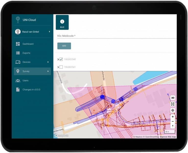
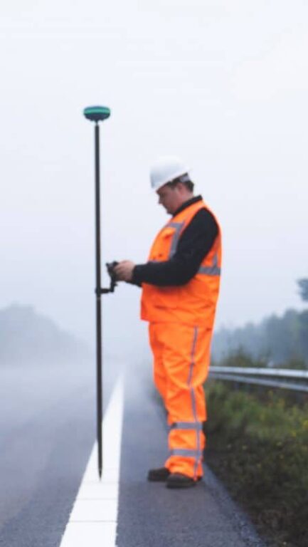
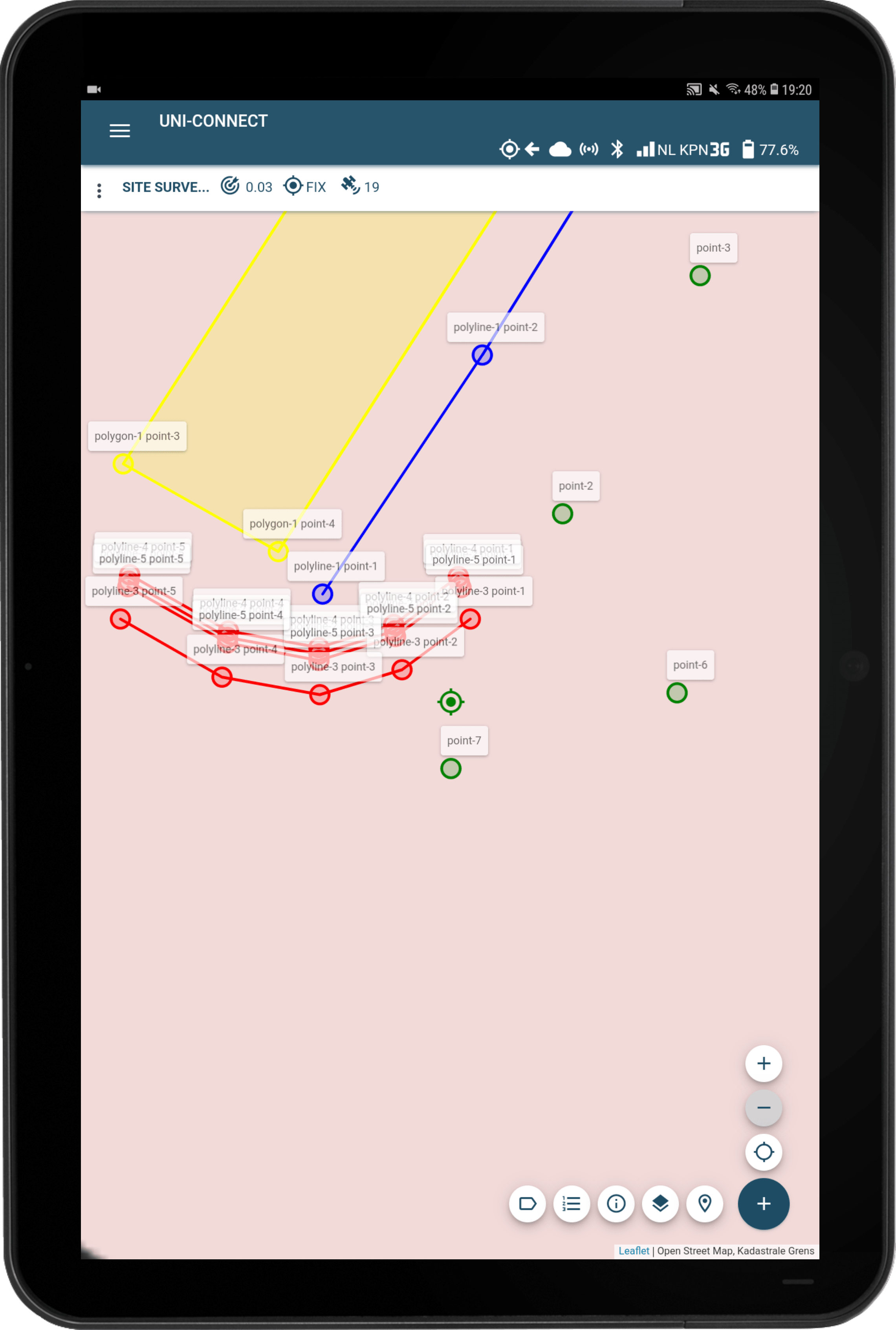
Skip to content

Affordable and easy surveying with GPS for infrastructure

Are you ready to start working more efficiently, productively, and within the timeframe set? We will get you on your way! Start surveying infrastructure with GPS.

The UNI-Complete package offers all you need to digitally survey, anything you want and completely independent. With this full package containing both hard- and software, you are more than able to register where new asphalt, concrete, pavement, and other top layers are laid, as well as drawing other objects such as roundabouts and traffic lights on a map.  

If you can use a smartphone, you can work with UNI-Complete. You are able to create new points, lines, and polygons with centimetre accurate GPS coordinates, and even in situations with open or closed trenches. 

When performing infra projects, you or your colleagues can now survey where new roads and elements will be created. You do not have to wait for surveyors to visit your project area anymore.  

And when you are done surveying, you send that data directly to the office for immediate review. Or in case you need to find another point in the field, your colleague can get it to you from behind his or her desk! That is efficient, productive, and an excellent example of teamwork! 

Working in the infrastructure sector?

Receive a brochure and discover the benefits of digital surveying with GPS


Surveying infra with UNI-Complete

Earning back your UNI-Complete investment is easy. Based on that €4995 and a 2-year access to UNI-Cloud and RTK-Premium and surveying 45 workweeks per year, you see what digital surveying can cost you in the table below. Yes, we say ‘can’. There are other costs as travel fare and salary involved, they impact how many hours you can survey digitally. Below, you see the costs per meter of asphalt, concrete, pavement, or another top layer when you work with the UNI-Solutions. We have more costs available, such as per traffic light or other objects in this blog.

Surveying 8 hours, per workday €11.84 per day 2,400 meters €0.005 per meter
Surveying 1 hour, per workday €11.84 per day 300 meters €0.04 per meter
Surveying 1 hour, per week €59.22 per week 300 meters €0.20 per meter
Surveying 1 hour, per 2 weeks €118.44 per 2 weeks 300 meters €0.39 per meter
Surveying 1 hour, per month €222.08 per month 300 meters €0.74 per meter

No open trench, but open-source

When you use UNI-Complete, you no longer have to create open trenches to research the current situation or measure electricity cables for traffic lights. You can directly lay asphalt, concrete, pavement, or any other new layer directly on the ground.

Due to our open-source approach and self-written UNI-Cloud API, are we able to connect with tons of other software and tools. This offers you the possibility to choose your own ultimate surveying experience, by arranging the equipment in your own tool kit.

Precise and (semi-)paved

Are you ready to work more precisely than ever before? Thanks to digital surveying, you can rely on centimetre accuracy and draw (new) top layers on the map. Paved, semi-paved, and unpaved layers can all be conveniently captured in the same file, resulting in comprehensive yet clear situation overviews.

UNI-Complete to start surveying immediately

UNI-GR2

The most universal GNSS receiver available. Receives GPS, Glonass, Beidou, Galileo, QZNSS, and SBAS to get you a CM accurate position and create polylines that represent all new top layers.

UNI-Connect

The easiest surveying software available for everyone who creates new infrastructure regularly. UNI-Connect works on any device with a browser and WiFi, you're easily ready to go!

UNI-Cloud

Gets your data from the field to your (home) office in real-time. Connects to the UNI-Cloud API and provides you with remote and phone support, whenever you like.

UNI-RTK Premium

With hundreds of base stations all over the world, UNI-RTK Premium gets you the CM accurate correction data you need.

Pole, Tablet & Mount

These keep you going. A weatherproof Android tablet to generate new data under all weather conditions, a two-meter carbon fibre survey pole, and tablet mount.

Tommy tells you how you survey infra accurately

These companies already survey their data

A. Hollander Infra

This family business uses their UNI-GR1 for the total package they offer their customers: including main and subcontracting of ground, road and hydraulic engineering projects.

HF Infra Solutions

HF Infra Solutions specializes in infrastructure construction, installation and maintenance of projects in various disciplines and use their multiple UNI-GR1s to become more productive.


NTP Infra

This regional contractor is active in the field of roads, soil, water, energy, and advice. In collaboration with the government, companies and institutions, NTP makes the living environment more functional and sustainable in a safe and healthy way, both in terms of infrastructure and environment.


KWS Infra

KWS designs, builds, maintains and manages infrastructure. Roads and public spaces. By land and water. Above and below ground. As a market leader in road construction and asphalt production, we are active throughout the Netherlands.

Rusch Asfalt

Rusch Asfalt BV is a modern asphalt contractor. They use their UNI-GR1 for both business and private customers.

Scholman Infra

 
Active in construction and maintenance of underground infrastructure, the UNI-GR1 helps them perform their job precisely.

Smink Infra

Smink Infra has been working for clients in the public and private sector for more than 65 years. We create sustainable quality in the realization of local infrastructural works.

A selection of our users

onderhoud-enschede-logo
en_GB

Leaving already? Why miss out on all the info? Enter your email below and we'll set up a date and time for your free 15 minute phone call with a digital surveying expert. No strings attached!

Project Sample Download

Please fill in your details and click send to be redirected to the download page of the AutoCAD Drawing, CSV File or PDF Report example of your survey data.