What are NMEA messages?
NMEA
‘NMEA’ is an acronym for The National Marine Electronics Association and is a non-profit association of manufacturers, distributors, dealers and educational institutions. NMEA already existed before any GNSS receiver was invented. The association was formed in 1957 by a group of electronics dealers to create a better way of communicating with manufacturers.
In the world of GNSS, NMEA is a standard data format supported by all GNSS receiver manufacturers. The goal of NMEA is to give equipment users the ability to mix and match hardware and software. NMEA formatted GNSS data also makes life easier for software developers to write software for a wide variety of GNSS receivers instead of having to write a custom interface for each receiver. For example: Mapit GIS or ArcGIS Collector software, accepts NMEA formatted data from any GNSS receiver and can graphically display the data in its live map. Without the NMEA standard, it would be time-consuming and expensive to write software.
NMEA messages
There are a few types of GNSS receivers with different capabilities, so there are also many various NMEA messages with different capabilities and useful information associated with the location. NMEA data can be transmitted via all sorts of communication interfaces such as USB, Serial connections, Wi-Fi, and many more. GNSS receivers can process necessary information like listed below:
- Quality of the location
- Number of satellites used in the location
- Number of satellites in view
- Accuracy of location
- Latitude, longitude and altitude
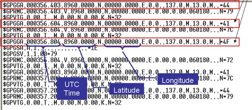
This is an example of what the structure of NMEA messages looks like:
Read our article: “ Which NMEA messages does the UNI support?” to see the messages supported by the UNI-GR1.